Help us improve in just 2 minutes—share your thoughts in our reader survey.
Category:State document images
From Ballotpedia
Pages in category "State document images"
The following 2 pages are in this category, out of 2 total.
Media in category "State document images"
The following 200 files are in this category, out of 1,086 total.
(previous page) (next page)- 2014-5-14-PF1-2013-Brownstown.jpg 400 × 300; 54 KB
- 2015 Kentucky horizontal wells.png 742 × 359; 168 KB
- 2017 Illinois oil and gas fields.png 531 × 692; 172 KB
- 2020 AR HD approved 1.jpeg 14,400 × 10,800; 13.7 MB
- 2021 AR SD approved 1.jpeg 14,400 × 10,800; 12.59 MB
- 730 maquoketacaves Iowa.jpg 730 × 230; 169 KB
- A map of oil and gas fields in Oklahoma.png 1,393 × 757; 1.31 MB
- Active unconventional wells PA-DEP.png 618 × 340; 527 KB
- Adeq-logo.jpg 300 × 103; 46 KB
- AGA v Frans PetitionforWrit 6-5-17.pdf ; 7.88 MB
- Air Monitoring Shelter-resized KY.jpg 3,296 × 1,822; 860 KB
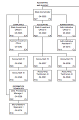
- AK comptroller org chart.png 237 × 360; 33 KB
- AK division of agriculture org chart.png 616 × 459; 56 KB
- AK Insurance Division org chart.PNG 695 × 641; 46 KB
- AK Letter of Intent.png 477 × 614; 95 KB
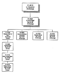
- AK lt. gov org chart.png 400 × 491; 58 KB
- AK RC org chart.JPG 766 × 587; 89 KB
- AK regulatory commission org chart.png 664 × 489; 119 KB
- AK State Legislative 2010 Census Map.jpg 1,006 × 792; 137 KB
- AK State Senate 2010 Census Map (interim 2012).jpg 2,397 × 1,731; 500 KB
- AL Agri Dept logo.JPG 99 × 99; 12 KB
- AL Atty Gen logo.JPG 130 × 127; 14 KB
- AL BOE final 2021.jpeg 2,550 × 3,300; 355 KB
- AL CD final 2021.jpeg 2,550 × 3,300; 442 KB
- AL CD map draft 1.jpeg 1,166 × 1,550; 126 KB
- AL CD pg1 draft 1.jpeg 1,128 × 831; 72 KB
- AL CD pg2 draft 1.jpeg 1,284 × 836; 73 KB
- AL DOE logo.JPG 92 × 91; 11 KB
- AL edu org chart.JPG 760 × 564; 84 KB
- AL HD final 2021.jpeg 2,550 × 3,300; 426 KB
- AL HD map draft 1.jpeg 1,128 × 1,605; 182 KB
- AL HD pg1 draft 1.jpeg 1,284 × 1,923; 229 KB
- AL HD pg2 draft 1.jpeg 1,166 × 2,048; 211 KB
- AL HD pg3 draft 1.jpeg 1,284 × 1,977; 235 KB
- AL HD pg4 draft 1.jpeg 1,166 × 2,048; 213 KB
- AL Independent Candidate Petition.jpg 471 × 606; 97 KB
- AL LtGov logo.JPG 108 × 114; 13 KB
- AL SD final 2021.jpeg 2,550 × 3,300; 468 KB
- AL SD map draft 1.jpeg 1,127 × 1,504; 149 KB
- AL SD pg1 draft 1.jpeg 1,229 × 1,874; 189 KB
- AL SD pg2 draft 1.jpeg 1,284 × 1,963; 198 KB
- AL State House 2010 Census Map.png 612 × 792; 929 KB
- AL Statement of Organization.png 477 × 614; 94 KB
- AL2014 Amendment 1.PNG 745 × 548; 116 KB
- AlaAppellatechart.gif 500 × 500; 12 KB
- Alabama Congressional map after 2010 Census.png 612 × 792; 878 KB
- Alabama exec org chart.png 1,700 × 2,200; 395 KB
- Alaska declaration.PNG 497 × 626; 59 KB
- Alaska enacted Senate map May 24 2022.jpg 2,550 × 3,300; 430 KB
- Alaska exec org chart.png 1,700 × 2,200; 227 KB
- Alaska oil and gas revenue, 1990-2013.png 600 × 371; 14 KB
- All oil gas wells in Kentucky (2017).png 765 × 344; 134 KB
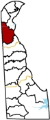
- Appoquinimink School District location in DE.jpg 73 × 173; 12 KB
- April 2011 Iowa Redistricting Map.jpg 871 × 543; 97 KB
- AR Campaign Contribution and Expenditure Report.jpg 458 × 504; 117 KB
- AR edu org chart.JPG 856 × 614; 87 KB
- AR Environment Logo.gif 640 × 150; 70 KB
- AR HD draft 1.jpeg 14,400 × 10,800; 11.49 MB
- AR NR org chart.JPG 753 × 534; 73 KB
- AR SD draft 1.jpeg 14,400 × 10,800; 10.12 MB
- AR State Senate 2010 Census Map.jpg 1,424 × 675; 256 KB
- ARBUCKLE v. GM.pdf ; 134 KB
- Arizona exec org chart.png 579 × 633; 56 KB
- Arizona oil and gas deposits.png 584 × 724; 320 KB
- Arkansas April 2011 Redistricting Map.jpg 274 × 189; 16 KB
- Arkansas exec org chart.png 824 × 608; 101 KB
- Arkansas seismic stations.png 474 × 442; 330 KB
- Athens County Ohio oil and gas wells July 2015.png 894 × 729; 1.39 MB
- Athens county oil and gas well map.png 438 × 385; 338 KB
- Autumn-scenic Lums Pond Delaware.jpg 540 × 262; 31 KB
- AZ auditor's office org chart.png 672 × 684; 365 KB
- AZ CD draft 1.jpg 768 × 1,024; 153 KB
- AZ CD draft 2.jpeg 7,200 × 9,600; 5.69 MB
- AZ CD draft 4.jpeg 10,800 × 14,400; 8.1 MB
- AZ CD draft 5.jpeg 7,200 × 9,600; 5.75 MB
- AZ CD draft 6.jpeg 7,200 × 9,600; 5.67 MB
- AZ CD draft 7.jpeg 7,200 × 9,600; 5.61 MB
- AZ edu org chart.JPG 1,024 × 589; 96 KB
- AZ LD draft 1.jpg 768 × 1,024; 157 KB
- AZ LD draft 10.jpeg 10,800 × 14,400; 11.39 MB
- AZ LD draft 2.jpeg 768 × 1,024; 158 KB
- AZ LD draft 3.jpeg 7,200 × 9,600; 5.84 MB
- AZ LD draft 4.jpeg 7,200 × 9,600; 5.65 MB
- AZ LD draft 5.jpeg 5,400 × 7,200; 15.68 MB
- AZ LD draft 6.jpeg 7,200 × 9,600; 5.75 MB
- AZ LD draft 7.jpeg 7,200 × 9,600; 5.85 MB
- AZ LD draft 8.jpeg 7,200 × 9,600; 5.75 MB
- AZ LD draft 9.jpeg 7,200 × 9,600; 5.76 MB
- AZ Nomination Paper.png 469 × 606; 73 KB
- AZ NR org chart.JPG 1,009 × 543; 66 KB
- AZ State Senate 2010 Census Map.jpg 2,592 × 3,168; 1.69 MB
- Boar photo small 383315 7.jpg 250 × 175; 51 KB
- Butte County, CA oil and gas well map.png 432 × 428; 359 KB
- CA 8,15,11 redistricting map.png 487 × 560; 167 KB
- Error creating thumbnail: File with dimensions greater than 12.5 MPCA AD draft 1.png 10,644 × 17,244; 26.01 MB
- Error creating thumbnail: File with dimensions greater than 12.5 MPCA AD final 2 2021.png 10,644 × 17,244; 18.53 MB
- CA AD final 2021.png 2,661 × 4,311; 5.29 MB
- CA BOE draft 1.png 1,152 × 832; 92 KB
- CA BOE final 2021.png 2,661 × 4,311; 4.77 MB
- Error creating thumbnail: File with dimensions greater than 12.5 MPCA CD draft 1.png 10,644 × 17,244; 23.1 MB
- CA CD final 2 2021.png 2,661 × 4,311; 5.32 MB
- CA CD final 2021.png 2,661 × 4,311; 5.32 MB
- CA China climate agreement.png 320 × 216; 271 KB
- CA Cont org chart.JPG 774 × 506; 49 KB
- CA DIR org chart.png 1,010 × 775; 143 KB
- CA edu org chart.JPG 987 × 595; 140 KB
- CA Form 470 Officeholder and Candidate Campaign Statement Short Form.jpg 766 × 588; 309 KB
- CA oil and gas wells May 8, 2014.png 501 × 577; 492 KB
- CA PUC org chart.JPG 755 × 570; 49 KB
- Error creating thumbnail: File with dimensions greater than 12.5 MPCA SD draft 1.png 10,644 × 17,244; 19.84 MB
- Error creating thumbnail: File with dimensions greater than 12.5 MPCA SD final 2 2021.png 10,644 × 17,244; 17.38 MB
- CA SD final 2021.png 2,661 × 4,311; 5.02 MB
- CA Sec of State org chart.JPG 1,156 × 608; 71 KB
- CA State Senate 2010 Census Map.jpg 1,510 × 1,958; 451 KB
- CA Tres logo.JPG 109 × 98; 10 KB
- California exec org chart.png 1,024 × 666; 165 KB
- California hydraulically fractured wells.png 886 × 649; 1.02 MB
- California oil and gas wells.png 489 × 562; 534 KB
- Carranza122011.pdf ; 135 KB
- CASampleApplication.pdf ; 289 KB
- CDPHE Colorado Logo.png 941 × 148; 22 KB
- City of Columbus, Ohio oil and ng wells July 2015.png 780 × 652; 1.05 MB
- City of Duluth organizational chart.PNG 756 × 728; 133 KB
- City of Modesto organizational chart.PNG 709 × 782; 134 KB
- City of Phoenix General Plan.png 461 × 699; 331 KB
- City of Phoenix organizational chart.PNG 960 × 734; 64 KB
- Class II injection wells Ohio July 2015.png 549 × 644; 160 KB
- CO edu org chart.JPG 1,185 × 633; 113 KB
- CO minor party petition sample page.jpg 438 × 734; 109 KB
- CO prop 112 impacts occupied and vulnerable areas combined.jpg 783 × 683; 192 KB
- CO State House 2010 Census Map.jpg 793 × 614; 167 KB
- CO State Senate 2010 Census Map.png 801 × 613; 165 KB
- CO Voluntary Campaign Spending Limits form.jpg 511 × 671; 118 KB
- Coalbed methane and natural gas production in Colorado.png 948 × 372; 13 KB
- COGCC-Logo.png 292 × 161; 11 KB
- Colorado exec org chart.png 594 × 624; 201 KB
- Colorado gas production 1952 to 2012.png 638 × 289; 44 KB
- Colorado oil and gas basins 2017.png 810 × 606; 773 KB
- Colorado oil and gas permit map.png 837 × 621; 700 KB
- Colorado oil and gas permits.png 786 × 563; 622 KB
- Colorado oil production 1952 to 2012.png 639 × 295; 45 KB
- Commonwealth v. Muniz.pdf ; 394 KB
- Components of BTEX.png 600 × 371; 14 KB
- Congressional Large Draft 3 5.jpg 5,400 × 7,200; 3.7 MB
- Connecticut DEEP Logo.jpg 336 × 310; 31 KB
- Connecticut enacted congressional map Feb 10 2022.jpg 1,857 × 1,590; 356 KB
- Connecticut exec org chart.png 518 × 621; 58 KB
- Cook Inlet Alaska map 2017.png 546 × 289; 35 KB
- Cook Inlet oil and gas legend 2017.png 598 × 255; 42 KB
- Counties with cities looking to secede, New York.png 461 × 360; 166 KB
- Crowders Mountain State Park NC.jpg 275 × 160; 10 KB
- CT Application for Nominating Petition.jpg 405 × 528; 78 KB
- CT HD 2021 plan.jpeg 3,300 × 2,550; 667 KB
- CT NR org chart.JPG 1,295 × 619; 104 KB
- CT PURA org chart.JPG 878 × 549; 48 KB
- CT SD 2021 plan.jpeg 13,200 × 10,200; 4.97 MB
- CT seaside aerial.jpg 500 × 362; 38 KB
- CT State House 2010 Census Map.jpg 3,456 × 2,592; 1.14 MB
- CT State Senate 2010 Census Map.png 3,456 × 2,592; 505 KB
- Cuomo tuition.jpg 702 × 429; 79 KB
- DE Candidate Filing Form.png 516 × 655; 59 KB
- DE edu org chart.JPG 863 × 626; 103 KB
- De Leon v Abbott.pdf ; 96 KB
- DE State House 2010 Kent Census Map.png 793 × 608; 324 KB
- DE State House 2010 NewCastle Census Map.png 680 × 860; 184 KB
- DE State House 2010 Sussex Census Map.png 632 × 793; 437 KB
- DE Tres org chart.JPG 562 × 635; 46 KB
- Delaware Courts organization chart.png 537 × 735; 134 KB
- Delaware exec org chart.png 503 × 563; 60 KB
- Delaware River Basin and the Marcellus Shale.png 348 × 303; 136 KB
- DENR-logo-color.jpg 569 × 361; 153 KB
- Denton County oil and gas well map.png 1,132 × 640; 1.18 MB
- DEP logo Pennsylvania.png 1,311 × 298; 53 KB
- Deq banner Michigan.jpg 480 × 130; 8 KB
- DEQlogo2 Montana.jpg 443 × 113; 16 KB
- DewateredBiosolids WA.jpg 1,368 × 1,015; 118 KB
- DNR Logo Iowa.jpg 300 × 200; 47 KB
- Doh-logo Hawaii.jpg 500 × 500; 106 KB
- DRBC and the Marcellus Shale.png 413 × 722; 235 KB
- Drilled and proposed fracking wells Kentucky 2017.png 800 × 516; 231 KB
- EO 20-43.pdf ; 317 KB
- FAX001 2603 1.pdf ; 300 KB
- Fayetteville Shale Arkansas Map 2017.png 1,198 × 1,182; 1.59 MB
- Fayetteville Shale in Arkansas.png 622 × 360; 391 KB
- Fayetteville shale upper.jpg 500 × 373; 77 KB